


Aux sources du Lot

Chabard
User

Length
12.7 km

Max alt
1295 m

Uphill gradient
336 m
Km-Effort
17.2 km

Min alt
1062 m

Downhill gradient
336 m
Boucle
Yes
Creation date :
2025-07-03 06:12:42.0
Updated on :
2025-07-03 10:09:00.961
3h55
Difficulty : Easy

FREE GPS app for hiking
 SityTrail
IGN / Geographical institutes
SityTrail Plus
The world is yours!
About
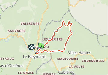
Trail Walking of 12.7 km to be discovered at Occitania, Lozère, Mont Lozère et Goulet. This trail is proposed by Chabard.
Description
Depuis le Bleymard
Positioning
Country:
France
Region :
Occitania
Department/Province :
Lozère
Municipality :
Mont Lozère et Goulet
Location:
Le Bleymard
Start:(Dec)
Start:(UTM)
558797 ; 4926589 (31T) N.
Comments